Hello All-
One of the disadvantages of a long cruise is that it takes you away from a lot of things you can't bring along; like friends, neighbors, and extended family. keeping in touch via cell phones and the Internet is relatively easy. However there is no substitute for being there, so this week Kathie is visiting her sister in California.
This photo shows the upper end of Pickwick Lake; the Tennessee River approaching the town of Florence Alabama. The farther bridge was built in 1834 and at one time carried trains.
Like many places we've vistied, this area has quite an interesting past. Here's a little info on the Tennessee River canal which bypassed Muscle Shoals (link). We showed a picture of some it's remnants the other day; this canal had a rather short working life since it was itself bypassed by a railroad and spent much of it's time as a diversion for floods.
Here is a scene from our last anchorage just a few miles downstream of Florence. At left you can see a small perfect beach. Hank liked this island and spent a lot of time chasing geese here. You can see here that all the study & hard work by Doug on this custom-built dinghy is paying off... an off-the-shelf rowing dinghy would have capsized a dozen times by now with Hank leaping around the way he does.
It is now five years since we bought the Winnie W. In that time we have done some work, done some cruising, sold a long time home and moved 150 miles to a new city. Now we are taking a pause in this major undertaking, the Great Loop cruise. Next week we will be traveling by car, and preparing to attend the America's Great Loop Cruisers Association rendezvous at Joe Wheeler Park along the river.
This photo shows a glorious sunset from an earlier anchorage.
We hope you all are well & happy-
Doug + Kathie
Sunday, September 30, 2007
Wednesday, September 26, 2007
A *3-State* Day
Hello all:
Yesterday we went from Tennessee into Mississippi and then into Alabama in the space of a few miles. Not a surprise when we started out at a place called "State Line Island." This first photo is looking between the islands, almost directly west, out into the main body of lower Pickwick Lake.
As we headed up the river, the crew of the Winnie W. relaxed because we did not have a tight schedule. This meant that when we saw a little cove to explore, we pulled back the throttle and turned in.
And when we did, we saw a wonderful spot. Here is a photo of an anchorage like many cruisers dream about. Totally sheltered, easy entrance, deep, a beautiful waterfall pouring over the scenic rocks, a beach just as close... the only problem is that for us, it was a little tight for swinging room.
We mentioned that the Tennessee River has long been an important commercial route; in the 1840s and 1850s hundreds of steam boats carried cargo & passengers along here.
This photo shows the remains of an early canal; this is the old Riverton lock. Most of the old canal works are flooded by the lake, but here you can see the ruined lock houses and in the background, the tops of the dikes dividing the old canal from the former path of the unimproved river channel.
In the foreground you can see a red nun bouy marking the modern channel, which is quite deep & safe; the buoy steers traffic away from the unsafe area.
Back then, the river had many shallow spots & rapids that could be dangerous. One stretch of shallow water, swift rapids, and rocky islands, was named Muscle Shoals... there's a theory that it was originally named Mussel Shoals after the plentiful shellfish.
This photo shows the lower end of Seven-Mile Island, the beginning of the Muscle Shoals area. The channel narrows here, and there are still rocks & shallows awaiting the careless skipper.
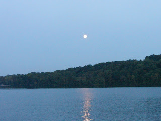
Our anchorage last night was (link to Google Map) at Buck Island in the Muscle Shoals area. Here is a photo of the moon rising over the river bank.
We had a little bit of trouble getting the anchor to set solidly, but after 3 tries we got it to dig in. Spent a peaceful night under a lovely full moon.... wish we could have had the waterfall too.... nah, it really doesn't get any better than this!
Hope you all are well & happy-
Doug & Kathie
Monday, September 24, 2007
Next step up... Diamond Island to Pickwick Lake
Hello all: we are continuing to cruise upstream on the Tennessee River. We made the next step up, locking through Pickwick Lock & Dam this afternoon.
Here is a photo from yesterday's anchorage: Doug giving the signal to put on some power in reverse to set the anchor. In the other hand, he's holding the anchor rode (nautical term for anchor rope) with one wrap on the sampson post. The wrap takes most of the strain but allows Doug to judge the tension, while watching abeam to see if the boat is moving backwards.... if yes, the anchor is dragging which is not good.
Eileen Quinn (link) has a song about this whole procedure : "The anchor dance." (she also has one called "I'm going to kill the captain..." ... just joking!!!)
Yes, it's still summer here in western Tennessee!
During the day's run we saw a crowd of young people having some good old-fashioned fun with a rope swing over the river. Here you see a very attractive young lady in a bikini going off the rope....
(we apologize that she is slightly out of focus due to hurtling thru the air)
And then the splash!
(Kathie took these photos; giving credit where credit is due, Doug advised to use the 'multiple exposure' setting... you are seeing #2 and #4 of 4 shots)
At Savannah, Tennessee, you can see the Cherry Mansion. This historic house was used by General Grant as headquarters before the battle of Shiloh, and was used as a hospital after the battle.
The house was built on an Indian mound similar to, but much smaller, than the one at Cahokia.
This morning we saw these mahogany beauties running downriver after a classic boat show at Pickwick Lake.
Right now we are anchored near State Line Island (catchy name) watching thunderstorms flash across the upper clouds in the distance. The island is half in Tennessee and half in Alabama; tomorrow, a bit down the river, we will cross into and out of Mississippi within about a 5 mile span.
Here is a link to a GoogleMap of our location- Doug & Hank explored the island, as usual, and report that this one is loaded with sticker vines & old broken bottles.
Best wishes to all
Doug & Kathie
Sunday, September 23, 2007
More cruising the Tennessee River
Hello all:
Let's start with some more lovely scenery. It is amazing how beautiful this country is, and we never get tired of looking. This is Pilot Knob, the tallest hill along the immediate riverbank for many miles, and a landmark for Tennessee riverboat pilots since the 1840s.
You often hear people use the phrase "sharp dividing line." Cruising gives you a keen appreciation for just how sharp dividing lines can be, for example, the line between water that is deep enough for your boat, and water that is not.
On the Tennessee River there are several sharp dividing lines. Some are both geographical and philosophical, for example, the line between places with cell phone coverage and those without. Our first picture showed high banks of shale and limestone, while here the shoreline is clay and sand with farmland nearby.
Along with the scenery, we often get a look at wildlife. Here a family of raccoons are rummaging along the beach, probably getting mussels.
We've seen deer swimming in the waterways several times along this trip, seen turtles, and huge needlenose gar jumped in front of the Winnie W. ....wish we'd got a photo of that!
The Great Loop is a great trip for birdwatching. Here is a huge flock of birds that Doug swears looked & flew like pelicans.
There are also eagles along the Tennessee River, although we haven't seen any. Osprey are common along North Carolina coast, so we haven't found them remarkable here... but this species (also called fish hawks) were extinct in the region and re-introduced.
There are a lot of small marinas along Kentucky Lake and the Tennessee River; boating is very popular.
This marina gets the prize for most interesting sign. It is mentioned in the cruising guides as an "interesting sign" but not what it looks like, so we thought we'd show you a picture.
A little further upriver (actually south, a bit hard to get used to) there is Lady Finger Bluff (link to topo map). Our Looper burgee has flown proudly with landmarks all along the way, some more famous... here you can see it in the breeze as we approach the bluff.
The legend is that in olden times, a pioneer cabin near this cliff was attacked by Indians. The woman of the pioneer family chose to leap from the bluff rather than surrender to the Indians.
Here is a better view of the same bluff. As the glaciers retreated, the area of central Tennessee rose in a sort of dome. This is the western edge of the "Highland Rim" around Nashville which was formed rising land & cut by the river during the Cenozoic era.
Kelley's Island (link to GoogleMap) is a cozy anchorage with very few mosquitos. The cruising guides recommended it. When we can, I like to anchor near islands and walk Hank on them, because that way we are less likely to trespass and Hank is less likely to disappear into the hills chasing a deer or something. When this photo was taken, Winnie W. had been underway for about 8 hours... a full day for a young dog... and he was eager to check out his new temporary territory.
This morning (Sunday) the Winnie W. continues to wend our way through the rocky hills of west Tennessee. A little bit of fog adds romance to the scene; you might have to click on the photo to see the big version but the river channel goes first to the right, then to the left.
The next set of bends in the channel present some cliffs, exposing more of the Highland Rim. This is another of those sharp dividing lines. At places along the lower Tennessee River, we see high cliffs of limestone on ones side, or the other. At other places, somewhat lower bluffs of clay & chalk. At no place along the lower river are there bluffs on both sides; so the river cut along the edge of two geologic formations.... no doubt this partially accounts for it's winding path.
Tonight the Winnie W. is anchored at Diamond Island (link to GoogleMap), just downstream from the 2nd lock & dam on the Tennessee River and not far from yet another dividing line, the border with Mississippi. We are also very close to the Shiloh battlefield.
Carrying the "dividing line" theme yet further, tomorrow morning we will (if all goes well) cross the latitude of our starting point at New Bern NC and will be on the southernmost part of our Great Loop cruise.
We hope that you are well and happy-
Doug and Kathie
Thursday, September 20, 2007
Cruising the Tennessee River valley
Hello all:
Here's our Thursday anchorage (link to GoogleMap) in Kentucky Lake, the first stage or pool of the Tennessee River. It's a beautiful area with a hint of autumn color appearing although the afternoons are still quite warm. In fact, it is very warm today and hard to believe it's been cool enough at night to start the colors turning!
One of the cruising activities that fills our day: when we anchor out, we take Hank ashore for a little exercise and to do his business. Here are Doug & Hank returning from a morning jaunt. In the pic below, you can see that Hank is pleased with the cruising lifestyle.
Along the way, we have been very interested in the history of areas that we cruise. The Winnie W. is now cruising along a corridor of Civil War history.
A brief overview: the Tennessee and Cumberland Rivers were important commercial highways in the 1850s; each had hundreds of steamboats carrying passengers & freight. Since the South had few railroads, this made the rivers strategically vital. General U.S. Grant, commanding a portion of the Union's western armies early in the war, saw the Tennessee River as an effective route of transporting his soldiers deep into the Confederacy.
The Southerners built forts to protect the waterways. Fort Henry was built on the Tennessee River, on a low bank next to the border with Kentucky. About 12 miles to the east, they built Fort Donelson to guard the Cumberland channel.
Grant launched a campaign into the South, using naval gunboats for support. This was part of the Union's overall strategic plan to split the Confederacy apart along the Mississippi. The gunboats took Fort Henry at a time when it was partly flooded (WikiPedia link), and then the army marched a short distance eastward overland to Fort Donelson (link). After three days of hard battle between the Confederate defenders with their cannon, and the Union soldiers supported by Navy gunboats, Fort Donelson surrendered. This was one of the few Union successes early in the war.
General Grant took his armies further into Confederate territory, turning a near defeat after a suprise attack at Shiloh (link) into a very bloody victory. Then he advanced to Memphis, and later to Vicksburg. This nearly impregnable walled town controlling the Mississippi River was the key to the whole Western campaign. After the fall of Vicksburg, President Lincoln summoned Grant to take command of the Army of the Potomac.
Back to the present- the Winnie W covered about 50 miles today, heading south (which is upstream) past the farms, resorts, and wilderness. Among other interesting sights, here is an out-of-use railroad bridge that has had the center spans removed.
Here is our anchorage (link to GoogleMap) among the islands of Harmon Creek. There is a twist side channel which pretty easy to follow, with red & green markers.
You can see the moon is well on the rise.
Just like this morning, Hank got another dinghy ride to another little island. This is a beautiful spot, isolated from both the mainland and the traffic on the main river channel.
A few fishermen have come by, they seem to appreciate the peace & quiet too.
Hank really enjoyed his evening romp on the island. He would have enjoyed it a lot more if there had been squirrels to chase, but the chance to simply run around was fun.
This photo is almost like a hi-tech Monet painting, with the water reflections of nature & motion.
Along the shore, Doug found lots of shells. Mussels abound in the Tennessee River & it's tributaries. The bivalve shells (top two) don't have the oblong shape of most mussels, but they grow to about 2 1/2 inches or 10cm across. The little spiral shells may be snails. Both are so plentiful that the beach of this little island is composed entirely of shells.
Hope you all are doing great!
Doug & Kathie
Wednesday, September 19, 2007
Upstream on the Ohio, now on the Cumberland
Yesterday we saw some people who were having a real adventure traveling down the Mississippi... in kayaks! I wanted to ask them if they'd seen Huck & Jim, but we were being swept past at 11 knots. Plus, it would have been rude to interrupt the guy's cell phone conversation!
This photo was taken just below Grand Chain, downstream from Cape Girardeau, Missouri (link to GoogleMap). You can see the rocks on the west shore of the river.
The Ohio River is quite different from the Mississippi. It is wider and shallower, with much more development along the banks. The Ohio has less current right now, which is lucky for us, and can change dramatically at higher water levels or stages.
This photo shows the confluence of the Ohio & the Mississippi, looking north-west from the mouth of the Ohio... in other words, the southernmost tip of Illinois! If you look, you can see a nav beacon displaying both red & greed for the two diverging channels.
There are two locks on the lower Ohio River, imaginatively named Lock & Dam #53 and Lock & Dam #52. We locked through the first one (#53 about 18 miles upstream from the Mississippi confluence) with only slight delay.
This photo shows the wide Ohio, crossed by powerlines and lined with smokestacks. At left are fellow Great Loop cruisers Sea Estate.
Wednesday afternoon we arrived at Lock & Dam #52 (link to GoogleMap) just east of Metropolis, Ohio, at about 4:30 pm. There was a lot of commercial traffic waiting to lock through. Sometimes the tow captains will agree to let recreational vessels share the lock chamber, if there's room. We were not offered that option by the lockmaster and it grew dark while we waited. Since it would be dangerous for us to run the river at night, and there was no place upstream to stop for many miles, we waited until this morning.
This photo is looking upstream on the Ohio River, about due north along this bend; you can see our traveling companion vessel Sea Estate and two islands at the mouth of the Cumberland River. Here we turn right to go up the Cumberland, through the hills of Kentucky.
Here is the view of the downstream side of Barkely Lock & Dam on the Cumberland River. This is one of two dams that hold back the Tennessee & Cumberland Rivers to form a huge lake in western Kentucky & Tennessee.
So for tonight, we are back in civilization (link to GoogleMap)*. We are on the TVA lake system which is a lovely and safe cruising area. We are really looking forward to the next week of our Great Loop cruise!
*addendum: if you "zoom out" on the map, you can see the Ohio River flowing northeast, and first the Tennessee River (left) then the Cumberland River (right) taking off from the Ohio; you can see we followed almost a clockwise route to get to the marina at Grand Rivers KY
Best wishes to all-
Doug & Kathie
This photo was taken just below Grand Chain, downstream from Cape Girardeau, Missouri (link to GoogleMap). You can see the rocks on the west shore of the river.
The Ohio River is quite different from the Mississippi. It is wider and shallower, with much more development along the banks. The Ohio has less current right now, which is lucky for us, and can change dramatically at higher water levels or stages.
This photo shows the confluence of the Ohio & the Mississippi, looking north-west from the mouth of the Ohio... in other words, the southernmost tip of Illinois! If you look, you can see a nav beacon displaying both red & greed for the two diverging channels.
There are two locks on the lower Ohio River, imaginatively named Lock & Dam #53 and Lock & Dam #52. We locked through the first one (#53 about 18 miles upstream from the Mississippi confluence) with only slight delay.
This photo shows the wide Ohio, crossed by powerlines and lined with smokestacks. At left are fellow Great Loop cruisers Sea Estate.
Wednesday afternoon we arrived at Lock & Dam #52 (link to GoogleMap) just east of Metropolis, Ohio, at about 4:30 pm. There was a lot of commercial traffic waiting to lock through. Sometimes the tow captains will agree to let recreational vessels share the lock chamber, if there's room. We were not offered that option by the lockmaster and it grew dark while we waited. Since it would be dangerous for us to run the river at night, and there was no place upstream to stop for many miles, we waited until this morning.
This photo is looking upstream on the Ohio River, about due north along this bend; you can see our traveling companion vessel Sea Estate and two islands at the mouth of the Cumberland River. Here we turn right to go up the Cumberland, through the hills of Kentucky.
Here is the view of the downstream side of Barkely Lock & Dam on the Cumberland River. This is one of two dams that hold back the Tennessee & Cumberland Rivers to form a huge lake in western Kentucky & Tennessee.
So for tonight, we are back in civilization (link to GoogleMap)*. We are on the TVA lake system which is a lovely and safe cruising area. We are really looking forward to the next week of our Great Loop cruise!
*addendum: if you "zoom out" on the map, you can see the Ohio River flowing northeast, and first the Tennessee River (left) then the Cumberland River (right) taking off from the Ohio; you can see we followed almost a clockwise route to get to the marina at Grand Rivers KY
Best wishes to all-
Doug & Kathie
Tuesday, September 18, 2007
Traveling Again
Hello all: For the past week, we've been playing tourist and visiting with family & friends.
Yesterday morning we started traveling again. On Monday, from Hoppie's Marina (link to Google Map) which is about 30 miles south of St. Louis, we traveled south (or down-bound) on the Mississippi River for about 110 miles. This is a long day for us even with a favorable current pushing the Winnie W's speed up to 10 knots.
Monday night we anchored in the Little Diversion Channel (link to GoogleMap) just south of Cape Girardeau.
At this writing, we are waiting to be locked up the Ohio River at Lock #52. Ohio River levels have been low plus there is much traffic, which means delays. We were hoping to make progress towards the Cumberland River and tonight anchor somewhere past this lock; at 7:30pm with darkness falling, we are now just below the lock and will get the first available morning lockage per this evening's lockmaster (keep your fingers crossed!).
Today (Tuesday) has been another long day; we weighed anchor at 6:20 am and started down the river in company with fellow Loopers Sea Estate and Xplorer. Here's the scene at O'Dark Hundred as we were leaving Little Diversion Channel. The channel (which is a drainage conduit to control Cape Girardeau's rainwater) had little current, and the Mississippi really grabbed our stern as we exited the channel! Another challenging day...
Although the Mississippi River is not friendly to cruisers, there are interesting things to see.Here is a photo that combines beautiful scenery, a wing dam seen extending into the left side of the channel (more about wing dams later), and a northbound barge on the right.
There is "radio etiquette" in discussions with commercial traffic. First, they're "tows" not barges. Calling them as they are approaching your pleasure vessel is crucial, with plenty of time to adjust your position relative to them, the current, and any potential obstructions.
Here's a photo of a 5x5 tow. It was taken after we passed it because we were busy being careful to avoid it. The biggest we've seen was 6 barges wide and 6 barges long! It's especially tricky around bends in the river. And look at his wake...
Tows prefer to have smaller vessels on the inside of a curve because they swing to the outside as they go around it; this is great because the tows have a huge prop wash plus the inside route is usually a bit shorter. However, there are occasions when it is necessary to go on the outside of the curve.
The system for managing river traffic is for pleasure vessels to call the approaching tow captain, stating the tow's position (looking at the chart and estimating where they are) so they know who you are calling; and then to state your position and respectfully request "instructions for passing."
The tow captain will ask you to pass "on the 1 whistle" ( or simply "on the 1"), or "on the 2 whistle" (or simply "on the 2"). The regional accents can make replies difficult to understand; most pleasure vessels listen carefully for the key "1" or "2." The guys claim that ladies get a more understandable answer.
At first the system seems complicated with the various permutations of approaching versus overtaking vessels, and who is where. After careful analysis, it can be boiled down to the system pictured: if they say "pass me on the 1" you move towards the right, and "pass me on the 2" you move past them on their left, whether you are approaching or overtaking. The whistles hanging from our radar screen serve as a reminder of which way to steer during these sometimes stressful encounters.
Here's a photo of Doug coping with traffic. We are going downstream, which means that we have both the "boost" (positive effect) of the 5 mph of Mississippi River current helping us reach our destination, but also the down side of being pushed into things, such as this upcoming traffic heading north on the Mississippi. You will notice that we are also next to a downgoing barge, who is trying to avoid the upgoing barge as well as us, and we have a buoy ahead of us that we want to avoid!
At 10:45am we reached the confluence of the Mississippi & Ohio Rivers. As the Winnie W. turned the corner, our speed dropped from 11 knots to 6.7 knots, because we are now going upstream on the Ohio River. Here's what it looked like. Notice the traffic!
We'll keep you posted of our progress, and appreciate your interest.
Our best to you, Kathie and Doug
Yesterday morning we started traveling again. On Monday, from Hoppie's Marina (link to Google Map) which is about 30 miles south of St. Louis, we traveled south (or down-bound) on the Mississippi River for about 110 miles. This is a long day for us even with a favorable current pushing the Winnie W's speed up to 10 knots.
Monday night we anchored in the Little Diversion Channel (link to GoogleMap) just south of Cape Girardeau.
At this writing, we are waiting to be locked up the Ohio River at Lock #52. Ohio River levels have been low plus there is much traffic, which means delays. We were hoping to make progress towards the Cumberland River and tonight anchor somewhere past this lock; at 7:30pm with darkness falling, we are now just below the lock and will get the first available morning lockage per this evening's lockmaster (keep your fingers crossed!).
Today (Tuesday) has been another long day; we weighed anchor at 6:20 am and started down the river in company with fellow Loopers Sea Estate and Xplorer. Here's the scene at O'Dark Hundred as we were leaving Little Diversion Channel. The channel (which is a drainage conduit to control Cape Girardeau's rainwater) had little current, and the Mississippi really grabbed our stern as we exited the channel! Another challenging day...
Although the Mississippi River is not friendly to cruisers, there are interesting things to see.Here is a photo that combines beautiful scenery, a wing dam seen extending into the left side of the channel (more about wing dams later), and a northbound barge on the right.
There is "radio etiquette" in discussions with commercial traffic. First, they're "tows" not barges. Calling them as they are approaching your pleasure vessel is crucial, with plenty of time to adjust your position relative to them, the current, and any potential obstructions.
Here's a photo of a 5x5 tow. It was taken after we passed it because we were busy being careful to avoid it. The biggest we've seen was 6 barges wide and 6 barges long! It's especially tricky around bends in the river. And look at his wake...
Tows prefer to have smaller vessels on the inside of a curve because they swing to the outside as they go around it; this is great because the tows have a huge prop wash plus the inside route is usually a bit shorter. However, there are occasions when it is necessary to go on the outside of the curve.
The system for managing river traffic is for pleasure vessels to call the approaching tow captain, stating the tow's position (looking at the chart and estimating where they are) so they know who you are calling; and then to state your position and respectfully request "instructions for passing."
The tow captain will ask you to pass "on the 1 whistle" ( or simply "on the 1"), or "on the 2 whistle" (or simply "on the 2"). The regional accents can make replies difficult to understand; most pleasure vessels listen carefully for the key "1" or "2." The guys claim that ladies get a more understandable answer.
At first the system seems complicated with the various permutations of approaching versus overtaking vessels, and who is where. After careful analysis, it can be boiled down to the system pictured: if they say "pass me on the 1" you move towards the right, and "pass me on the 2" you move past them on their left, whether you are approaching or overtaking. The whistles hanging from our radar screen serve as a reminder of which way to steer during these sometimes stressful encounters.
Here's a photo of Doug coping with traffic. We are going downstream, which means that we have both the "boost" (positive effect) of the 5 mph of Mississippi River current helping us reach our destination, but also the down side of being pushed into things, such as this upcoming traffic heading north on the Mississippi. You will notice that we are also next to a downgoing barge, who is trying to avoid the upgoing barge as well as us, and we have a buoy ahead of us that we want to avoid!
At 10:45am we reached the confluence of the Mississippi & Ohio Rivers. As the Winnie W. turned the corner, our speed dropped from 11 knots to 6.7 knots, because we are now going upstream on the Ohio River. Here's what it looked like. Notice the traffic!
We'll keep you posted of our progress, and appreciate your interest.
Our best to you, Kathie and Doug
Sunday, September 16, 2007
Small steps, big steps, good friends
Hello again, all: We haven't traveled very far along the Mississippi River. For the last week or so, the Winnie W. has been docked in the St. Louis area while we visited & played tourist. First we stayed in Alton, Illinois, a few miles north of St. Louis, and then we traveled down the river about 40 miles to Kimmswick, where have been tied up over the weekend. Here are some photos of friends and family.
The first photo is cousin Pam with Kathie in front of the Monk's Mound at the Cahokia historic site on the Illinois side of the Mississippi River.
Kathie and sailing friend Jane, whom we met in North Carolina and who now lives in the St. Louis area, under the Gateway Arch.
There are many interesting things to do & see in the St. Louis area. Friends Russ and Deb from North Carolina flew in to visit us; Russ is from Sainte Genevieve, a beautiful historic French town south of the city. We were glad to see Russ and Deb, and meet his friends and family. The first stop was his home town, Sainte Genevieve. Here's a photo of us with Russ and Deb.
Here is a photo of the whole gang (L to R): Doug, Sherry, Deb, Joan, Russ, Kathy, and Kathie. Front and center (of course) is Hank.
Russ and Sherry's grandmother had a restaurant in Sainte Genvieve, and Russ had many interesting stories about his family and growing up in this wonderful town. He and his family have many friends and connections in the area.
Later,we visited the Chaumette winery about 40 miles south of the city; the next day, a Farmer's Market and the St. Louis Zoo (which was great); and today, the botanical garden (pictured).
St. Louis is organized around neighborhoods and we toured many; the architecture is spectacular and many areas are restored or in the process of restoration. Russ and Sherry know many recent and remote historical details about the neighborhoods and the people who built St. Louis. We would come back in a minute!
Here is a photo of us enjoying a superb meal in one of the many excellent local restaurants.
We went to the Piper Palm House for brunch this morning, which was elegant!
Recently we have taken small steps in traveling along the Great Loop, but large steps in meeting new friends and renewing old friendships & in learning about people & places along the way. We are grateful for Russ and Deb's visit and the kindness of Sherry, Joan, and Kathy in hosting us in St. Louis.
Our best to you all, Doug and Kathie
Tuesday, September 11, 2007
Not "just another day"
Hello All-
First we'd like to observe and honor the remembrance of September 11th.
Let us all give a moment of quiet thought, thanks, sympathy for the victims & their families.
Let us also think about the true principles & values of freedom, democracy, honor, & duty. These things never change and while they are often co-opted into cheap slogans, they are the greatest wealth that we, as a people, have. Let us also remember that this richness of spirit can be found in any person whatever their status, education, skin color, religion, or credit rating.
Over the past couple of days, we've taken a break from cruising.... well not really. We've been visiting family & friends, playing tourist, and working on the boat. We have learned a lot and really enjoyed the St. Louis area.
We visited the site of Cahokia, an ancient city (link) along the Mississippi. This city was built in the period 800 A.D. to 1250 A.D. supported by the farming of corn in the rich valley soil. These Native Americans created a civilization spreading their influence over the Mississippi and Missouri and Ohio River watersheds, with trade from the oceans up into the Lake Superior region. The most impressive remains of their city is called the Monks Mound (link ), named after a group of French religious brethren who lived at the site during the early colonial period, after the Native American builders had been long gone.
Another legacy from the ancient inhabitants of this region: the Piasa bird (link). Although at first glance, it looks like a bit of childish grafitti, but it is really an ancient petroglyph that has been "touched up" in modern times.
An interesting coincidence is that we arrived at almost the same time as "the hippie boat," an ambitious project of free spirits who call themselves the Miss Rockaway Armada (link). Assembling their rafts from mostly free materials, intending to drift down the Mississippi, they have no money or licenses or permits, but they do have at least one motor and enough savvy to keep out of the way of commercial traffic.
An altogether different type of vessel, although also one that expresses freedom, is here in Alton now. The LST-325 (link to HazeGray naval history site) is one of the last surviving WW2 landing ships, a veteran of the Sicily campaign and D-Day. This ship was saved from the scrapyard by group of tough old salts who raised the money, made her seaworthy to cross the Atlantic again, and sailed her themselves from Greece to Mobile, Alabama (link to 1st Memorial LST-325 website).
Here is a photo of the Clark Bridge over the Mississippi River, almost right overhead of our slip in the marina. It's named after William Clark the explorer. His name is almost always given second billing in "Lewis & Clark" (link to L&C journals). The same highway crosses the Missouri River on the Lewis Bridge. These men deserve to remembered for the key part they played in the early expansion of the United States.
So we're here in Alton (link to GoogleMap), planning to stay for a few more days, with plenty to do. Is this "cruising"? We think so....
Best regards to all
Doug & Kathie
Subscribe to:
Posts (Atom)