We set out from Ditto Landing Marina, just south of Huntsville. We anchored at a very nice island (link to map) about 50 miles upriver, traveling once again with our friends Bob & Sue on their trawler Tom-Kat. Tonight we are anchored at another island between Nickajack Lock & Dam and the city of Chattanooga.
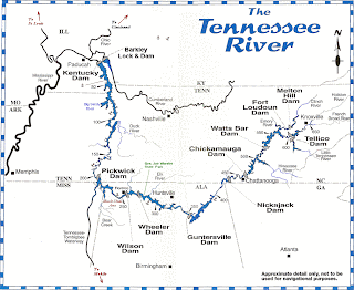
This map is adapted from the excellent Tennessee River Cruise Guide written by Fred Myers; it should give you an idea of our Tennessee River travels and the scope of this cruising area. The markers are in statute miles from the mouth of the river.
The next photo shows the entrance to the marina
 basin at Ditto Landing. A settler named James Ditto established a ferry here in 1807 and this spot on the river has been named for him ever since. Once this was a thriving port, sending tons of cotton down the rivers to New Orleans and thence to the world. But times change; the final blow to this river port was the boll weevil in the early 1900s, and the post office of the town here closed in 1905.
The marina basin entrance channel is rather narrow. This photo was taken standing on one bank and looking slant-ways out toward the main river (on right). That's an early morning fog in the hills.

Here are the bluffs upriver a few miles from Huntsville; at the bottom right you can see the perfect reflection slightly distorted by the Winnie W's wake as we go by. Kathie takes marvelous photos!

Next, on this overcast & occasionally drizzly day, we met the Coast Guard cutter Ouichita with a work barge.
This crew is at work maintaining the river channel; you can see the red & green buoys they have prepared to put in place. Without these "road signs" on the water, it would be far more difficult & dangerous for cruisers... and more importantly, for commercial shipping!

This is our companion vessel Tom-Kat passing Painted Bluff, a few miles below Nickajack Lock & Dam. Although this area has much fertile soil and is great farm country, it sits atop a rocky plateau that the river has cut through over the eons.
You can see that as we travel further east, closer to the Appalachians, the terrain is getting higher.
 This is just across the border of Alabama & Tennessee, heading north this time. The bridge you see connects the town of South Pittsburg with points east & south. It is one of the few suspension bridges across the Tennessee River. It is not a small bridge, and behind it you can see the towering southern rim of the Cumberland Plateau. The rocky ridge peaks are 1,100 feet above the river level.
Here (link to Goggle Map) is the spot this photo was taken from; the navigation channel actually goes on the right (very narrow) side of Long Island, then the river bends around to the right (east) as we go upstream.

Okay; now we are up into the Cumberland Plateau region, above Nickajack Dam and approaching Chattanooga from down-stream. This area is called the Grand Canyon of Tennessee, and Doug apologizes that this photo (one of the few taken by Doug) cannot do the sight justice.
Hope you all are well & happy-
Doug & Kathie

1 comment:
Well, I'm totally hooked on your cruising adventure, to the point that your blog is now one of my automatic home pages on Mozilla.
Recent pix have been quite beautiful. And, I always enjoy the adventures of Hank, The Boat Dog.
So, what are the pros and cons of cruising with others? I note that you have been with the Tom Kat for a while now.
Post a Comment