Hello all:
We started a couple days ago anchored on Chickamauga Lake, just upstream from Chattanooga on the Tennessee River. The day's run took Winnie W. and Tom-Kat farther upstream to the Hiwassee River.
The first photo shows the mouth of the Hiwassee River, once the site of a major Cherokee town. Now it is a nature preserve and we like to think the original citizens would still recognize it.
The 2nd photo shows one of the navigation markers at the mouth of the river. The old saying "Red Right Returning" is easy to remember, and when going upstream it's easy to figure out which side is which. But this red-green-red could be a puzzler if you didn't study the chart & recognize the junction of two navigation channels. This buoy is behind an island that has an "oxbow" (channel parallel to the main river) around it; we want to enter the Hiwassee River which goes upstream from the middle of the oxbow. Because we are headed into the Hiwassee River, this buoy is "green" for us on the right part of the "Y" which means we keep it on our *left* as we head into the Hiwassee; if we were to continue around the oxbow (bend) back towards the TN River (taking the left part of the "Y"), we'd consider it "red" and keep it on our *right*. This is important because the colors indicate shallow places for both the Hiwassee and the oxbow!
The Hiwassee River flows westward out of the mountains of North Carolina. We cruised upstream, kidding about 'going home,' and found a beautiful anchorage about 15 miles from the N.C. border. We could have gone a little closer, but the lower Hiwassee is formed by the joining of the Ocoee River to the upper Hiwassee, and both of these are tough places to travel by canoe, much less a 36' tugboat.
We've also been kidded about how every other picture seems to be of Hank... usually riding in the dinghy with Doug. Well, it's all about Hank (link), for sure. But here is a slightly different picture: Kathie riding in the dinghy with Hank.
This is probably not one of our best photos, partly because Doug took it. You can see that he did not take care to keep his shadow from partly blocking the picture, although he did try to get the scenic cliffs in the background. What this picture doesn't show is how crazy they all three are, two adults taking a 70-pound dog in a 9' rowing dinghy.
The Hiwassee River is part of the pool formed by the Chickamauga Lock and Dam on the Tennessee River. It's mouth is about 55 miles upstream from Chattanooga. The channel is fairly deep, 12'+, and it's well marked. There is some commercial traffic to & from the industrial plants near Charleston TN. Above that, the river is unmarked but still has 6'+ depths for at least another seven miles or so.
Here is a view looking upstream from our anchorage. These rocks have fallen into the river fairly recently, and there is still dirt clinging to the tops of the rocks.
Now here is a photo that was definitely taken by Kathie. This is a closer look at the tumbled rocks & cliff in the above picture, with stunning reflections.
What you can't see in this photo is that although the water is plenty deep for a cruiser to pass, there are LARGE rocks lurking under the surface, companions of these fallen boulders that are visible above. Just like navigating the Georgian Bay and the North Channel!
Currently we are anchored in Richlands Creek, near Dayton TN (link to Google Map). As we were getting anchored and settled in for the evening, a fisherman stopped by to talk a while. Hank and Doug are discussing local history with Steve, a new friend of us all.
Among other things, we learned that the University of Tennessee (UT) "Volunteer Navy" is the twelfth largest in the world, as judged by gross tonnage of vessels. They fly an orange flag with a white anchor on their boats! UT is one of only two schools that have stadiums on the water and fans can go to games by boat. A large proportion of the Volunteer Navy attends home games, with so many boats rafted together that participants in the festivities can walk across the Tennessee River as they go from boat to boat!
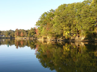
A view of the creek yesterday (Monday 10-29) evening
The same view this morning! As of this writing, we have waited 4 hours for the fog to clear enough so that we can safely proceed on.
Best wishes to all for safe trips in your journeys today! Doug and Kathie
Monday, October 29, 2007
Sunday, October 28, 2007
Cruising: not really sure why it's fun, but it sure is!
Hello All-
OK, we've been cruising the Tennessee River Valley for over a month. Tonight, Sunday Oct 28, we are anchored on the Hiwassee River (link to map). We've been cruising new (to us) territory for six months now. Are we crazy?
Well... yes.
Isn't everybody?
Cruising isn't a cutting edge, ka-zing ka-zow, kind of sport... although it can be, if you choose a different boat and/or different venues. It can also be much more relaxing & placid. There are as many different ways to cruise as there are people out cruising, and that includes the 200 or so currently "doing the Loop" along with us.
One of the great things about the Great Loop voyage is that it encompasses so much of North America, geographically & sociologically. It only includes one foreign country, Canada; although our Canadian Looper friends (see Beardstown entry) say that the U.S. is LOT more foreign. However it covers the swampy Southeast, so familiar & dear to us; the Chesapeake, the Hudson River & Erie Canal, the Great Lakes each having it's own individual character & beauty, the inland rivers, the Gulf Coast, and the long & varied Florida coast. There are big cities, small quaint towns, and wilderness, in every area and with every shade of local color. So the Great Loop is all charted & mapped, but there is something to discover almost every day.
This first photo shows Winnie W. and Tom-Kat at the dock in downtown Chattanooga. The third boat beside (to the right) Tom-Cat is another Looper, the Carol Anne.
A true saying: "Cruising consists of fixing your boat in exotic, romantic, and incredibly inconvenient locations." The Winnie W. had a brief unplanned stop in Chattanooga, beset by two problems. Neither were serious, but the combination meant that further cruising without repairs would entail hardship & difficulty. Electricity is vital to modern life, and that's where the problem(s) lay. The alternator and the generator both felt neglected and decided they wanted attention and cuddling.
Here's some real electricity- a nuclear power plant along the Tennessee River.
The alternator, attached to the main engine so that it provides 12 volt DC power to the boat and charges the batteries while we are underway, had not been acting right for some time. It's a new alternator of larger capacity (90 amps) than Winnie W's original, and so the first step was to seek further technical information about it. The problem is that it only provides a maximum of 13.8 volts which is not enough to fully charge the boat's battery bank, compounded by erratic operation. The manufacturer told us the output peak voltage is factory-set and when it senses peak voltage for a certain period of time, it shuts off so as not to overcharge the batteries and boil off electrolyte (a common problem with car batteries). Both these characteristics are built into the alternator as features, and not fixable.
Fortunately, we had had the Winnie W's original alternator rebuilt and kept on board as a spare. So Doug simply swapped alternators, a relatively simple job.
Here's another in the long series of 'Hank Acting Cute In The Dinghy' series, with a slight difference... Kathie took this shot from the stern seat of the dinghy. The rocky bluff is near our anchorage on the Hiwassee River.
Solving our other electricity problem was more complex & time-consuming. Our diesel-powered generator, which supplies 120V AC power to our floating household and also charges the 12V batteries, began making horrible screeching noises and filled the engine room with acrid smoke Thursday (10-24) night. It sounded like a dragging belt, only louder. So Doug let the smoke clear and then began diagnosing the problem... yes it was a dragging belt, and the reason was that the coolant pump driven by the belt had locked up.
This was a more complex problem and required teamwork. First, Kathie got us a short-notice reservation at a Chattanooga marina, no small feat on one of the last weekends of the season. Friday we tied up to the dock. Then, Bob on our companion vessel Tom-Kat dug through the Internet to find a wide range of possible part #s and local suppliers for a replacement coolant pump. Doug sweated and banged his knuckles getting the old pump out (while conserving it in recognizable pieces), then fetched the new pump by bicycle. We all had lunch on Saturday after embarking once again on the cruise, and no shortage of electricity!
Here are Winnie W. and Tom-Kat in a lovely peaceful anchorage far up the Hiwassee River.
So, cruising is witnessing the world's incredible beauty, meeting new people in new places, and it's also self-reliance. It's working with others. Cruising is keeping track of the boat's electricity, and also fuel, food stocks, and water tankage. It is living with a smaller ecological footprint but also taking charge of that footprint. While cruising, we are subject to Nature's whims in a way that cannot be experienced by any other means, but it is also taking control of one's own destiny in a way that is totally opposite to the modern life.
We think it's fun! Best wishes to all, Doug and Kathie
Thursday, October 25, 2007
Upstream toward Chattanooga
Hello all-
We set out from Ditto Landing Marina, just south of Huntsville. We anchored at a very nice island (link to map) about 50 miles upriver, traveling once again with our friends Bob & Sue on their trawler Tom-Kat. Tonight we are anchored at another island between Nickajack Lock & Dam and the city of Chattanooga.
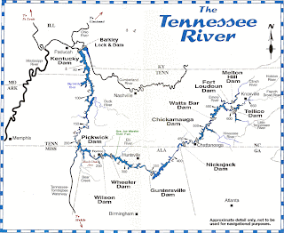
This map is adapted from the excellent Tennessee River Cruise Guide written by Fred Myers; it should give you an idea of our Tennessee River travels and the scope of this cruising area. The markers are in statute miles from the mouth of the river.
The next photo shows the entrance to the marina basin at Ditto Landing. A settler named James Ditto established a ferry here in 1807 and this spot on the river has been named for him ever since. Once this was a thriving port, sending tons of cotton down the rivers to New Orleans and thence to the world. But times change; the final blow to this river port was the boll weevil in the early 1900s, and the post office of the town here closed in 1905.
The marina basin entrance channel is rather narrow. This photo was taken standing on one bank and looking slant-ways out toward the main river (on right). That's an early morning fog in the hills.
Here are the bluffs upriver a few miles from Huntsville; at the bottom right you can see the perfect reflection slightly distorted by the Winnie W's wake as we go by. Kathie takes marvelous photos!
Next, on this overcast & occasionally drizzly day, we met the Coast Guard cutter Ouichita with a work barge.
This crew is at work maintaining the river channel; you can see the red & green buoys they have prepared to put in place. Without these "road signs" on the water, it would be far more difficult & dangerous for cruisers... and more importantly, for commercial shipping!
This is our companion vessel Tom-Kat passing Painted Bluff, a few miles below Nickajack Lock & Dam. Although this area has much fertile soil and is great farm country, it sits atop a rocky plateau that the river has cut through over the eons.
You can see that as we travel further east, closer to the Appalachians, the terrain is getting higher.
This is just across the border of Alabama & Tennessee, heading north this time. The bridge you see connects the town of South Pittsburg with points east & south. It is one of the few suspension bridges across the Tennessee River. It is not a small bridge, and behind it you can see the towering southern rim of the Cumberland Plateau. The rocky ridge peaks are 1,100 feet above the river level.
Here (link to Goggle Map) is the spot this photo was taken from; the navigation channel actually goes on the right (very narrow) side of Long Island, then the river bends around to the right (east) as we go upstream.
Okay; now we are up into the Cumberland Plateau region, above Nickajack Dam and approaching Chattanooga from down-stream. This area is called the Grand Canyon of Tennessee, and Doug apologizes that this photo (one of the few taken by Doug) cannot do the sight justice.
Hope you all are well & happy-
Doug & Kathie
Monday, October 22, 2007
Visiting Rocket City by Water
Hello all!
"Rocket City" refers to Huntsville AL, and we've been in its environs for a few days.
We explored the Elk River which flows southward from central Tennessee into Alabama and joins the Tennessee River on Wheeler Lake. This first photo is pretty enough, but also demonstrates the old navigator's saying "Don't ever drive your boat towards a spot where birds are standing." The Great Blue Heron is standing on a log which is grounded in very shallow water, or perhaps snagged on a rock or stump.
Moonrise over autumn colors along the Elk River in northern Alabama (faintly seen at upper left). This year, the fall colors are not as vivid because of prolonged dry weather... or so they say... but it's still wonderful to watch the change of seasons.
One last Elk River scene: this is Buzzard Roost Bluffs.... catchy name, eh?
We've seen larger cliffs & rocks along the way, and will see more, but this is one of Kathie's nicer photos, and it is a pretty place regardless of what sights may lie further up or down the main rivers.
We anchored out two nights in a row in the same spot (link to map); it was such a pretty & secure place that we felt no need to hurry on.
Another Great Blue Heron staked out his spot at sunset, ignoring the smokestacks in the background. He returned to this same spot the next evening, too.
Doug & Hank had two days to explore this beautiful cove in Hank's dinghy. This shot is looking northward across Wheeler Lake on the Tennessee River; you can see a small island at the mouth of the Elk River.
You can also see that Hank is pretty casual about taking rides in the dinghy. He's been doing it for a few months now, and is far too confident in his "sea paws."
But Hank has good reason to be confident, he's very agile & athletic. We try to give him enough exercise when we're cruising. Here are two action shots of Hank playing on the beach. This first photo shows him eyeing a tennis ball and taking off like the proverbial rocket.
In the second photo (these were taken on the multiple-exposure setting), a split-second after the first, Hank still has his eye on the tennis ball while he leaps over a big fallen tree.
It's true that this involves a different skill set than leaping into a small tippy dinghy, but Hank doesn't know that!
This is what makes Huntsville "Rocket City." The Loopers toured the city including the US Space and Rocket Center at Redstone Arsenal, which is where the U.S. space program first took off!
Those old enough to remember Project Apollo (or techno-geeks who have followed the space program) will recognize this as the Saturn V, the largest rocket ever built and the work-horse of the United States' moon landings.
NASA is now working on a new heavy-lift booster (link) which will utilize similar engines, along with the re-usable boosters such as those on the Space Shuttle. This will make it possible to continue progress in orbit and beyond; the International Space Station and a Moon base.... maybe even sending people to Mars.
Here's the L.E.M. or Lunar Excursion Module.
Projected manned missions to the Moon or to Mars include landing vehicles that look remarkably like this one... hey, it worked, why mess with success! Seriously, it would be difficult to include all necessary functions in a lander that looked much different.
This is like the dinghy for future space cruisers!
Best wishes to all-
Doug & Kathie
Friday, October 19, 2007
Close Encounters with Wildlife
Hello All-
Snakes, armadillos, a skunk, countless deer... we can't imagine what we'd do if Hank broke free and ran down the skunk which seems to rummage around the Joe Wheeler Park lodge every night. Hank did get loose and chased an armadillo one evening, with results that were unsatisfactory to both parties.
Here is a photo of Doug & Hank on a sunny afternoon, overlooking Wheeler Lake on the Tennessee River. We had just seen a lot of deer when this was snapped, and Hank is still keeping an eye for them.
Let's play "Count The Deer." There are at least six within the frame of this photo... one second after Kathie clicked the camera, we saw that many waving white tails bounding away through the woods.
Deer are not fearful of people, but they are wary of rowdy dogs. They are difficult to see when they freeze, utterly motionless, and watch you walk by. Even Hank seems to miss them much of the time, until one of the herd will snort a warning signal and they all bolt.
A few days back when we first arrived here, we gave a mis-count on the number of Great Loop cruising boats attending this rally... there were 78 here at the Joe Wheeler State Park marina. Around 250 people attended, many arriving by cars since their boats were elsewhere. It was a lot of fun getting together with friends that we've made along the way, meeting some new folks, learning a little about the navigational challenges ahead along with the anchorages and ports waiting to welcome us.
Sincere best wishes to all-
Doug & Kathie
Sunday, October 14, 2007
A short trip on the river, beginning the AGLCA meeting
Hello all: This morning (Sunday, Oct 14th) as the sun was peeking over the edge of the world, we got underway from the Florence Harbor Marina to head further up the Tennessee River. It was not a long days run, but we had in mind to get thru the Wilson Lock (link) before it was tied up with commercial traffic. This plan succeeded and we are now docked with about 50-60 boats full of other Great Loop cruisers, plus some folks who came by land who have recently finished the Loop or are contemplating the trip.
Our boat is usually the slowest whenever we travel with others, and this photo shows our Looper friends ahead of us who *held* the second lock (Wheeler Lock) until we could get there; this was really kind of them, because there was a 3x4 barge that would have had to be locked through in pieces and we would have waited 3 hours for the next upbound lockage.
On a chilly morning, the water steams. On Saturday, we were awakened to strains of a patriotic song in country-western style. Kathie jumped out of bed to get this photo which shows a bass tournament about to get underway, in fact these 10 guys are the final round competitors; amazingly, the weights of their total catch ranged from 38 to 41+ pounds, with the top two pros only 13 ounces apart! The prize is $100,000!
The restaurant at the marina had a unique pool where you can look down at the fish in the harbor. At the upper right you can see a huge needle-nose gar... looks like an alligator without the legs...
Over the past week, we drove a rental car from northern Alabama to North Carolina and back. We attended a wedding, had appointments with doctors & dentists, met with a few old friends. The car ride was about 150 miles less than the Winnie W. has traveled so far; and totaled about 4+ days highway driving versus 5 months cruising by water, about 2 miles less than 3,000 in the rental car!
Wilson Lock is worth some mention- it is the highest lock on the Great Loop with a lift of 93.5 feet at normal water levels; it is the sixth tallest lift in the US, behind 5 locks on the Columbia and Snake Rivers in the Pacific NW. It is named after President Woodrow Wilson, and was originally intended to provide both power & transportation for a munitions plant in World War 1 (link). Now it has the largest generating capacity of any TVA dam. The lower gates swing open but the upper gate opens vertically. This lock chamber was so tall that it cut off GPS and radio signals!
Here is the view from Wilson Lake, just above (upriver, heading east) the lock & dam. You can see the arches across the top of the dam, an old-fashioned architectural flourish; also the Renaissance Tower in Florence AL overlooking the lake & the dam... awesome view and a popular restaurant.
A happy reunion with Bob & Sue from Tom-Kat, who met us at the dock along with our friends Bob & Lyn from Legrace. One of the biggest joys of cruising is the camaraderie & friendships. It is also nice to have extra help so as to not ram the dock!
We rounded The Silver Foxes (boat on the right of the photo) and saw there was a whole gang to greet us and help us! It really felt good that all these Loopers would turn out to say hello when we arrived.
Best wishes to all
Doug & Kathie
Friday, October 12, 2007
Small Update
Good morning/evening/night, wherever you all are: It's been a 5 month boat ride and now the end of a week-long whirlwind tour of 5 states by car. We've seen some of you and it was great to touch base. More updates to follow!
Best wishes, Kathie and Doug
Subscribe to:
Posts (Atom)